The subsurface contrast between downtown Prince George and the Hart Highlands is stark. Near the confluence of the Fraser and Nechako rivers, you hit soft silts and clays quickly, while the upper benches transition into dense glacial till and fractured bedrock within a few meters. This variability, driven by the city's position at the bottom of a glacial lake basin, makes seismic tomography the logical first step before committing to a foundation design. We rely on refraction and reflection surveys because they map the transition from the overburden—often sensitive Nechako Formation clays—into the competent rock underneath. For sites near the cutbanks along River Road, slope-stability analysis later integrates these velocity profiles to assess potential failure surfaces.
When you need to know if that refusal is a boulder or true bedrock, a velocity tomogram answers the question that a drill rig leaves open.
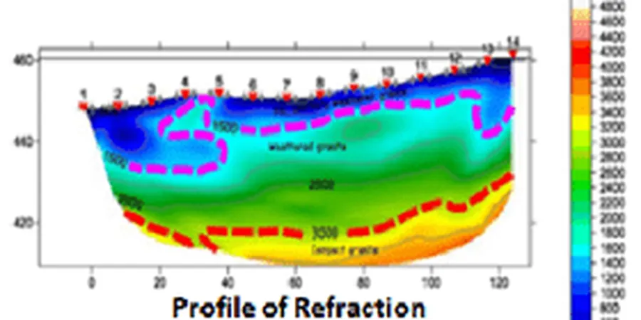
Methodology applied in Prince George
Typical technical challenges in Prince George
Under the current NBCC 2020, Prince George sits in a moderate seismicity zone with a 2% in 50-year hazard for short-period ground motions that demand a Site Class determination. The problem is that the default assumption—Site Class C—does not hold on the soft soils along the Nechako floodplain. A blind design based on borehole data alone can miss a velocity inversion: a soft clay layer beneath a stiffer crust that amplifies ground motion. Seismic tomography, particularly combined with MASW for the upper 30 meters, directly measures the shear-wave velocity profile needed for a defensible Site Class assignment. We have seen sites where the corrected Vs30 drops below 180 m/s, pushing the classification into Site Class E. That changes the structural load demand significantly. The local practice of digging a test pit to 3 meters and extrapolating is inadequate here; the glaciolacustrine stratigraphy is simply too layered and too variable across the city's terraces.
Our services
Our seismic work in Prince George is structured to feed directly into the geotechnical design package. The deliverables you receive are not just raw seismograms; they are interpreted cross-sections that align with borehole logs and material boundaries. Common applications in the region include:
Refraction Microtremor (ReMi) Surveys
Passive-source method effective on constrained lots near downtown where active hammer sources cannot generate sufficient energy. We use linear arrays and process with slowness-frequency transforms to extract the fundamental-mode Rayleigh wave dispersion curve.
Rippability and Excavation Assessment
Velocity-based classification of rock mass for trenching and cut operations. We correlate P-wave velocity ranges to Caterpillar D8–D10 ripper performance charts, critical for the siliceous metasediments found in the Cariboo terrane east of the city.
Bedrock Depth Mapping for Infrastructure
Continuous 2D profiles along proposed utility corridors and bridge approaches. This is particularly useful near the Cameron Street Bridge area, where the buried bedrock channel influences pier depth.
Vs30 Profiling for Seismic Site Class
Hybrid refraction and surface-wave acquisition to measure the time-averaged shear-wave velocity in the upper 30 meters, as required by NBCC Table 4.1.8.4.A. We deliver a signed Site Class letter suitable for permit submission.
Frequently asked questions
How deep can a seismic refraction survey image in the Prince George area?
It depends on the source energy and array length. With a standard 48-channel spread at 5-meter spacing and a weight-drop source, we can typically resolve the bedrock surface down to about 30 meters in the glacial till. To go deeper—say for a proposed bridge pier—we extend the spread and use a larger accelerated weight drop. The dense, overconsolidated till here transmits energy well, so we can often exceed the rule-of-thumb 1/5th spread-length depth limit.
What is the cost of a seismic tomography survey in Prince George?
A basic 2D refraction line of 115 meters with 24 geophones typically falls in the range of CA$4.170 to CA$8.140, depending on site access, terrain, and the number of shot points. A full 3D grid or hybrid refraction-MASW program for a larger site will be at the upper end of that range. The estimate includes mobilization within the Prince George area, data acquisition, tomographic inversion, and a signed engineering report.
Can you do this work in winter when the ground is frozen?
Yes, but with caveats. Frozen ground increases the near-surface velocity and can mask the true water table. We use a hammer drill to seat geophones below the frost line and apply static corrections during processing. In Prince George, where frost can penetrate 1.5 meters by February, we prefer to schedule surveys between May and October, but winter work is feasible with proper coupling and longer shot gathers.
How does seismic tomography compare to just drilling boreholes?
Drilling gives you a precise log at one point. Seismic tomography gives you a continuous image between points. In the glacial stratigraphy of Prince George, where buried channels and erratic boulders are common, a borehole can hit refusal on a boulder and call it bedrock. The tomogram shows whether that high-velocity zone is an isolated block or a continuous horizon. The two methods are complementary; we use the seismic data to reduce the number of boreholes needed.
Do you need traffic control or road closures for urban surveys?
For surveys within city streets or along highways like Highway 97, yes. We coordinate with the City of Prince George and the Ministry of Transportation for lane closures if the spread crosses a traveled lane. On private lots or industrial yards, we work within the site and no road closure is needed. Our field crew has OFA Level 1 certification and carries full traffic control plans for urban work.